Mardi Himal does not stand alone. It is the ridge that rises from the slopes directly below Machhapuchhre, the sacred, unclimbed Fishtail. The two summits sit barely 2.5 to 3 km apart, which is why the Mardi trek is so often sold as the closest way to stand beneath the most famous peak in the Annapurna massif.
Mardi Himal, at 5,587 m, is the ridge and summit complex rising from the south and south-west slopes directly below Machhapuchhre, which stands at 6,993 m. The two are part of the same southern arm of the Annapurna massif, separated by a high col at around 5,200 m. Their summits are close: Mardi Himal sits at 28.4736°N, 83.9275°E and Machhapuchhre at 28.495°N, 83.94917°E, putting them roughly 2.5 to 3 km apart, with the Fishtail to the north-east. In landscape terms, Mardi Himal is the shoulder Machhapuchhre rests on.
That geography is the whole reason the Mardi trek exists where it does. The trail climbs the forested spur, then the open ridge, until the south face of Machhapuchhre fills the sky. The wider setting, the neighbouring peaks and how this arm fits the range, is on our position in the Annapurna massif page, and the rock and ice underneath it on our geography and geology page.
Machhapuchhre has never been officially summited. The only confirmed attempt was a British expedition in 1957, organised and led by Lt. Col. Jimmy Roberts, the man later called the father of trekking in Nepal. Wilfrid Noyce and A.D.M. Cox climbed the north ridge to within about 46 m (150 ft) of the top, reaching roughly 6,947 m, and then stopped. King Mahendra had granted permission to climb but barred the team from setting foot on the actual summit, and they kept that promise. Noyce later published the only climbing record of the peak, "Climbing the Fish's Tail."
No climbing permits have been issued since. After 1957, Roberts is reported to have asked the Nepal government to keep Machhapuchhre permanently off-limits, and it agreed. There is no documented dated decree, and the BBC notes that exactly how Roberts secured the ban remains a mystery, so we flag the "banned in year X" claims seen on some sites as unverified. A report that a New Zealand climber, Bill Denz, illegally reached the summit in the early 1980s is likewise unconfirmed. The defensible statement is simple: climbed to within about 46 m in 1957 under terms that forbade the summit, and closed ever since.
The reason the mountain stays closed is, in the end, reverence. Machhapuchhre is sacred to the Gurung communities of the region and to the people of Chhomrong, and in Hindu framing it is described as a home of the god Shiva. These two readings are distinct: for the Gurungs the sacredness is local and ancestral, while the Shiva association is the Hindu one, and both are attributed to their sources rather than merged. Whichever frame you use, the result on the ground is the same: the summit is left untouched.
This is part of why the Annapurna foothills feel the way they do. The Mardi trail passes Gurung and Magar villages with their own monasteries and prayer flags, walking through a living culture that holds the mountain above it as holy. We cover the religion of the valley, and the full story of the 1957 expedition, on our sacred mountains and spirituality page.
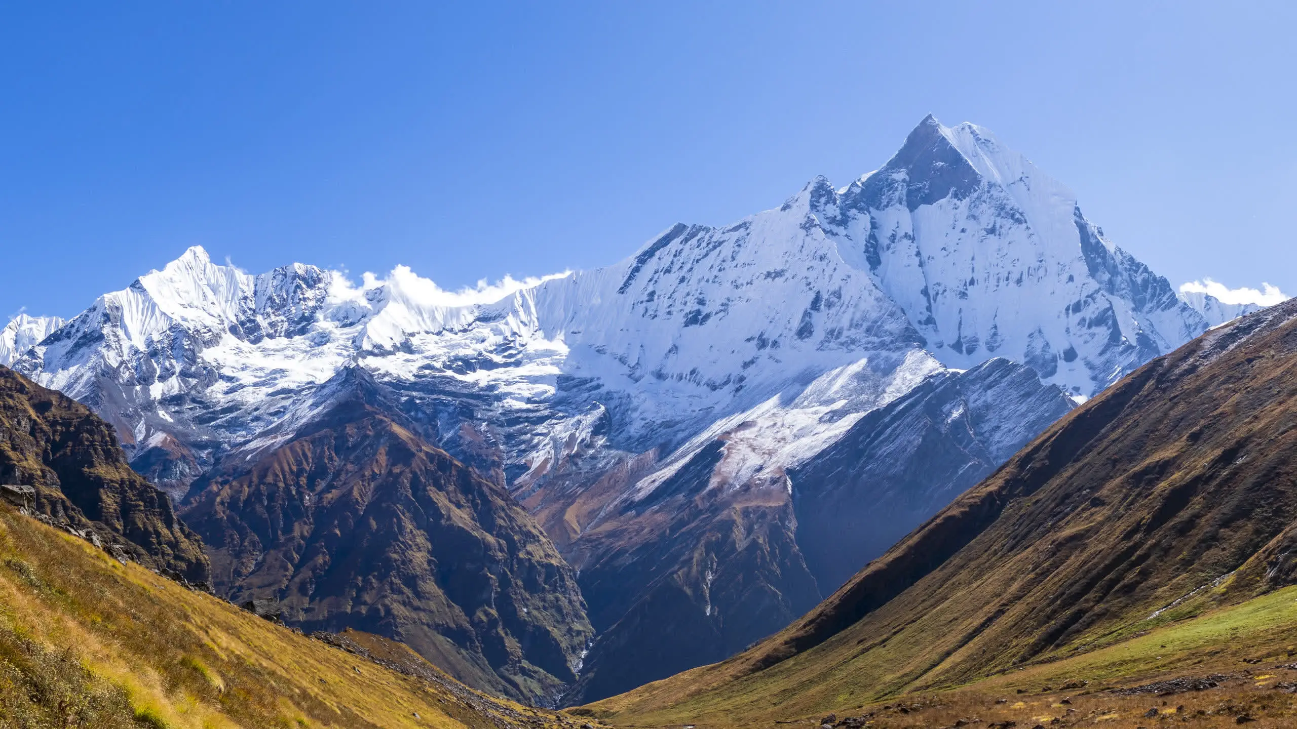
The name Machhapuchhre means fishtail, and the mountain earns it: a twin summit connected by a sharp ridge that, from the right angle, reads as a fish's tail flicking up at the sky. But that twin profile is not visible from everywhere. The classic fish-tail silhouette shows best from the west and north-west, for example from around Annapurna Base Camp. From the south, including the Mardi ridge, the two summits line up and the mountain reads instead as a single, soaring pyramid.
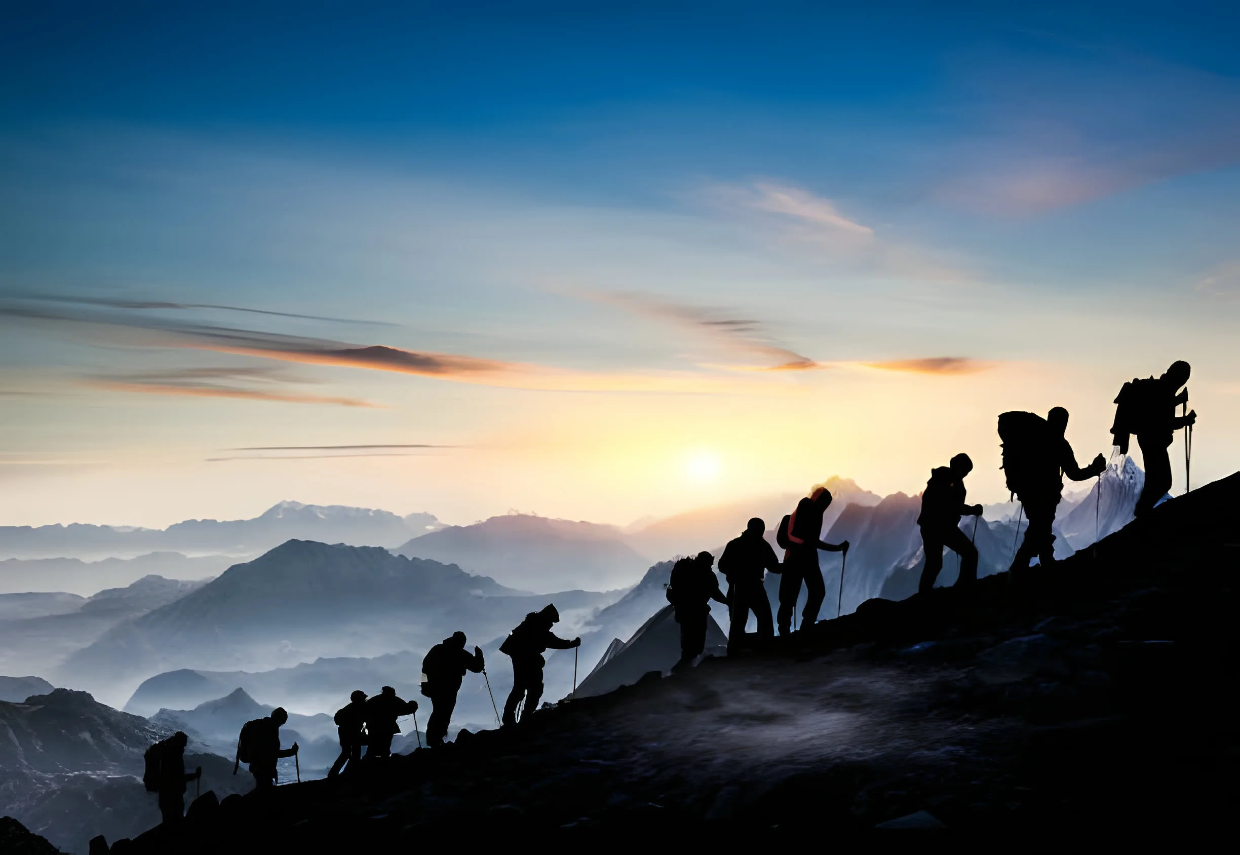
So from Mardi you do not get the postcard tail. What you get is the south face, and you get it close. Standing under that wall is the payoff of the trek, and it is why Mardi is repeatedly called the closest accessible viewpoint of Machhapuchhre. If you want the tail as well, the views from the Sanctuary side are the complement: the two trails see two faces of the same mountain. The high days of the Mardi walk are on our Mardi Base Camp page.
Because the route spends its best days directly beneath the south face, some operators market the Mardi Himal trek as the Machhapuchhre trek or the Fishtail trek. The labels point to the same trail. There is no separate, legal trek that climbs Machhapuchhre, because the peak is closed; the Mardi ridge and Mardi Base Camp are as near as a trekker can lawfully get. Mardi Himal itself, by contrast, is open, designated a trekking peak and first climbed in 1961, a history we trace on our first ascent page.
If the draw is standing beneath the Fishtail, the Mardi route is the most direct way to do it from Pokhara. The full day-by-day plan, with permits and grades, is on our Mardi Himal trek page.
Mardi Himal is the ridge and summit complex that rises from the south and south-west slopes directly below Machhapuchhre. The two peaks are part of the same southern arm of the Annapurna massif, separated by a high col at roughly 5,200 m. Their summits sit only about 2.5 to 3 km apart, with Machhapuchhre to the north-east at 28.495°N, 83.94917°E and Mardi Himal at 28.4736°N, 83.9275°E. In simple terms, Mardi Himal is the shoulder of the Fishtail, which is why the Mardi trek is so often described as the closest way to stand beneath Machhapuchhre. They are not two unrelated mountains seen from one trail; they are one continuous piece of high ground.
No. Machhapuchhre has never been officially summited. The only confirmed attempt was a British expedition in 1957, led by Lt. Col. Jimmy Roberts. Wilfrid Noyce and A.D.M. Cox climbed via the north ridge to within about 46 m (150 ft) of the top, reaching roughly 6,947 m, then stopped. King Mahendra had given permission to climb but forbade setting foot on the actual summit, and the team complied. No climbing permits have been issued since, and the mountain is closed.
Machhapuchhre is held sacred. It is revered by the Gurung communities and the people of Chhomrong, and in Hindu framing it is described as a home of the god Shiva. After the 1957 expedition, Jimmy Roberts is reported to have asked the Nepal government to keep the peak permanently off-limits, and it agreed. There is no documented dated decree, and the exact mechanism is, in the BBC's words, a mystery; today the prevailing reason is simply that the mountain is sacred and therefore forbidden.
Not the classic twin-tail silhouette. The famous fish-tail profile, two summits connected by a sharp ridge, shows best from the west and north-west, for example from around Annapurna Base Camp, where the two points line up to look like a fish's tail flicking at the sky. From the Mardi ridge you are under the mountain's south face, where the summits stack and it reads as a steep, soaring pyramid rather than a split tail. What Mardi gives you instead is proximity: you stand closer to that south wall than almost any other accessible viewpoint, which is the trek's signature reward.
Some operators market the Mardi Himal trek as a Machhapuchhre or Fishtail trek, because the route spends its high days directly beneath the south face of Machhapuchhre. The terms point to the same trail. There is no separate trek that lawfully climbs Machhapuchhre, since the peak is closed. The Mardi ridge and Mardi Base Camp are as close as a trekker can get to it. Our full route is on the trek page.
Very close. The upper Mardi viewpoint and Mardi Base Camp, at around 4,500 m, sit almost directly under the south face of Machhapuchhre, with only the connecting high ground between you and the Fishtail. Because the summits of Mardi Himal and Machhapuchhre are barely 2.5 to 3 km apart, the mountain fills the skyline. This is why Mardi is repeatedly called the closest accessible viewpoint of Machhapuchhre.
Yes. Unlike Machhapuchhre, Mardi Himal is open. It is designated a trekking peak by the Nepalese government and was first climbed in 1961. For most visitors, though, the goal is not the 5,587 m summit but the Mardi ridge and Base Camp, reached on a teahouse trek from Pokhara. The history of who first reached the top is covered on our first ascent page.
We run small-group trips from Pokhara every Saturday from September to May. We also run private trips any day. A $50 deposit holds your place. Pay the rest on arrival in cash or by card.