Mardi Himal is a small peak in a giant's shadow: a 5,587 m ridge tucked below Machhapuchhre in the Annapurna Himal. Its rock was built by a continental collision, its valley by a single medieval landslide, and its slopes by glaciers that still feed the Mardi Khola today.
Mardi Himal stands in Kaski District, in Gandaki Province, within the Annapurna Himal of central Nepal. Wikipedia places the summit at roughly 28.4736 N, 83.9275 E, almost directly north of Pokhara and immediately south of Machhapuchhre, the fishtail peak. The headline elevation is 5,587 m (18,330 ft), though trekking operators often quote 5,553 m or 5,555 m instead; no official source settles the difference, so we treat the lower variants as unverified.
The mountain is not a free-standing summit so much as the high end of a long ridge that climbs out of the Annapurna foothills towards Machhapuchhre, from which it is separated by a col at about 5,200 m. That intimate relationship with the fishtail peak is set out on our Machhapuchhre relationship page, and the wider context of the range is covered in our position in the Annapurna massif guide.
The Annapurna peaks are built from two great stacks of rock. The bulk of the high massif belongs to the Greater (also called Higher) Himalayan Sequence, a thick slab of high-grade metamorphic rock, schists, gneisses and quartzites, that was thrust southward over the older Lesser Himalaya along a major fault, the Main Central Thrust. Sitting on top of that, towards the crest and beyond, are the Tethyan sediments: a roughly ten-kilometre-thick pile of marine limestones and shales, Cambrian to Cretaceous in age, laid down on the old northern margin of the Indian plate when this was a shallow sea rather than a mountain range. In the Annapurna area that Tethyan cover has been folded and faulted through several phases of deformation, which is part of why the geology of the region reads as such a tangle of tilted, overturned beds.
Machhapuchhre and the Annapurnas combine these metamorphic and sedimentary rocks, with the limestones and the high-grade schists sitting close together near the Main Central Thrust. All of it was lifted into the sky by the collision of India with Asia, the same event that raised the entire Himalaya. The rock that forms Mardi Himal's ridge is part of this same crystalline slab, and the naming of the peak and its place in local culture is covered on our name and meaning page.
The Himalaya is young and still growing. India is driving north into Asia at around 67 mm a year, of which roughly 20 mm a year is taken up by thrusting along the Himalayan front. Published estimates for how fast the range itself rises vary by method, from about 5 mm a year to around 7 mm a year, with the very highest rates (close to 10 mm a year) recorded at Nanga Parbat far to the west, not here. The figures are estimates rather than a single agreed number, so we quote a range. The collision that does all this began tens of millions of years ago when India, having drifted north across the vanished Tethys ocean, ran into Asia; the continental crust had nowhere to go but up, stacking the slices of rock that now make the Annapurna skyline.
That ongoing uplift, combined with monsoon rain and glacial erosion, is why this corner of Nepal is so steep and so prone to collapse. The same forces that raised the ridge also strip it back down, feeding rock and silt into the rivers below. The mechanics of that drainage are set out on our rivers page.
Behind Machhapuchhre lies the Sabche Cirque, a vast, glacially carved amphitheatre rimmed by Machhapuchhre, Annapurna III and Annapurna IV. It is the high bowl from which the Seti Gandaki escapes through a famously narrow gorge, in places only a couple of metres wide. Mardi Himal sits on the southern rim of this same high country, and the glaciers and snowfields on its slopes feed the Mardi Khola, the river that gives the mountain its name and that the trail follows in its lower stages.
The Sabche Cirque was also the catchment that swallowed the medieval Annapurna IV rockslide. Around 1190 to 1255 CE the western flank of Annapurna IV collapsed, sending roughly 23 cubic kilometres of rock nearly 3,000 vertical metres down into the cirque, shearing about 500 m off the summit. The debris dammed the Seti gorge and built the ~200 m-deep sediment fan that Pokhara now sits on; the work was published in Nature by Lavé and colleagues. The full water story, including a warming climate and shrinking glaciers, is on our rivers page.
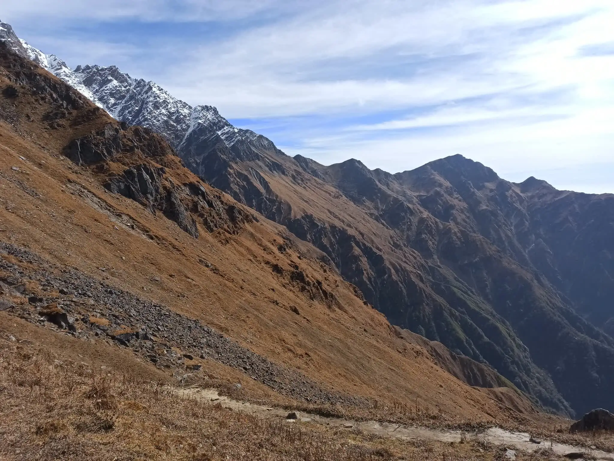
For walkers, the geology shows itself as terrain, and the Mardi Himal trail crosses it in clean bands. The lower and middle slopes are forest: oak, rhododendron and bamboo, dense and humid, climbing out of the Pokhara foothills. Higher up the trees thin to a ragged treeline, then give way to open alpine ridge and grassland with the big peaks suddenly close. The upper lodges sit at about 3,580 m and base camp at about 4,500 m, near the limit of comfortable walking before the ground steepens towards the summit ridge. Each band is a response to altitude and aspect: the warm, wet forest below, the wind-pruned shrubs and junipers at the treeline, then the bare rock, snow and moraine of the high ridge, where the underlying crystalline slab finally shows through the thinning soil.
Because the trail gains height quickly through these bands, the weather and the air change just as fast; how to read both is set out on our weather page. The day-by-day walking, and what each band looks like in season, is on our trek and our base camp pages. The history of the first climb to the top is on our first ascent history page.
Mardi Himal stands in Kaski District, Gandaki Province, within the Annapurna Himal in central Nepal. Wikipedia places the summit at roughly 28.4736 N, 83.9275 E, directly south of Machhapuchhre and a short distance north of Pokhara. The peak rises from the south and south-west slopes below Machhapuchhre, separated from it by a col at about 5,200 m.
The most cited figure is 5,587 m (18,330 ft), from Wikipedia. Trekking operators frequently quote 5,553 m or 5,555 m instead. No government or Himalayan Database confirmation resolves the difference, so we use 5,587 m as the headline figure and treat the lower variants as unverified alternatives.
The high peaks of the Annapurna region belong to the Greater (Higher) Himalayan Sequence, a thick slab of high-grade metamorphic rock, schists, gneisses and quartzites, thrust over the Lesser Himalaya along the Main Central Thrust. Above it sit the Tethyan sediments, marine limestones and shales laid down on the old northern margin of India. Machhapuchhre and the Annapurnas combine these metamorphic and sedimentary rocks, all of it lifted by the India-Asia collision.
The Sabche Cirque is a vast, glacially carved amphitheatre rimmed by Machhapuchhre, Annapurna III and Annapurna IV. It is the high bowl from which the Seti Gandaki escapes through a narrow gorge. It was also the catchment that received the medieval Annapurna IV rockslide, and it remains a source of avalanches and the megafloods that shaped the Pokhara valley.
Estimates vary. The Indian plate pushes north at roughly 67 mm a year, of which about 20 mm a year is absorbed by thrusting along the Himalayan front. Published uplift estimates for the range run from about 5 mm a year up to around 7 mm a year, with the highest rates (close to 10 mm a year) reported at Nanga Parbat far to the west. The figures are estimates from different methods, so we quote a range rather than a single number.
The Mardi Himal trail climbs through clearly banded terrain: oak, rhododendron and bamboo forest on the lower and middle slopes, then a thinning treeline, then open alpine ridge and grassland. The upper lodges sit at about 3,580 m and base camp at about 4,500 m. The full walking guide is on our trek page.
Yes. Around 1190 to 1255 CE the western flank of Annapurna IV collapsed in a mega-landslide, sending roughly 23 cubic kilometres of rock nearly 3,000 vertical metres into the Sabche Cirque. The debris dammed the Seti gorge and built the deep sediment fan Pokhara now sits on. The study, by Lavé and colleagues, was published in Nature.
We run small-group trips from Pokhara every Saturday from September to May. We also run private trips any day. A $50 deposit holds your place. Pay the rest on arrival in cash or by card.